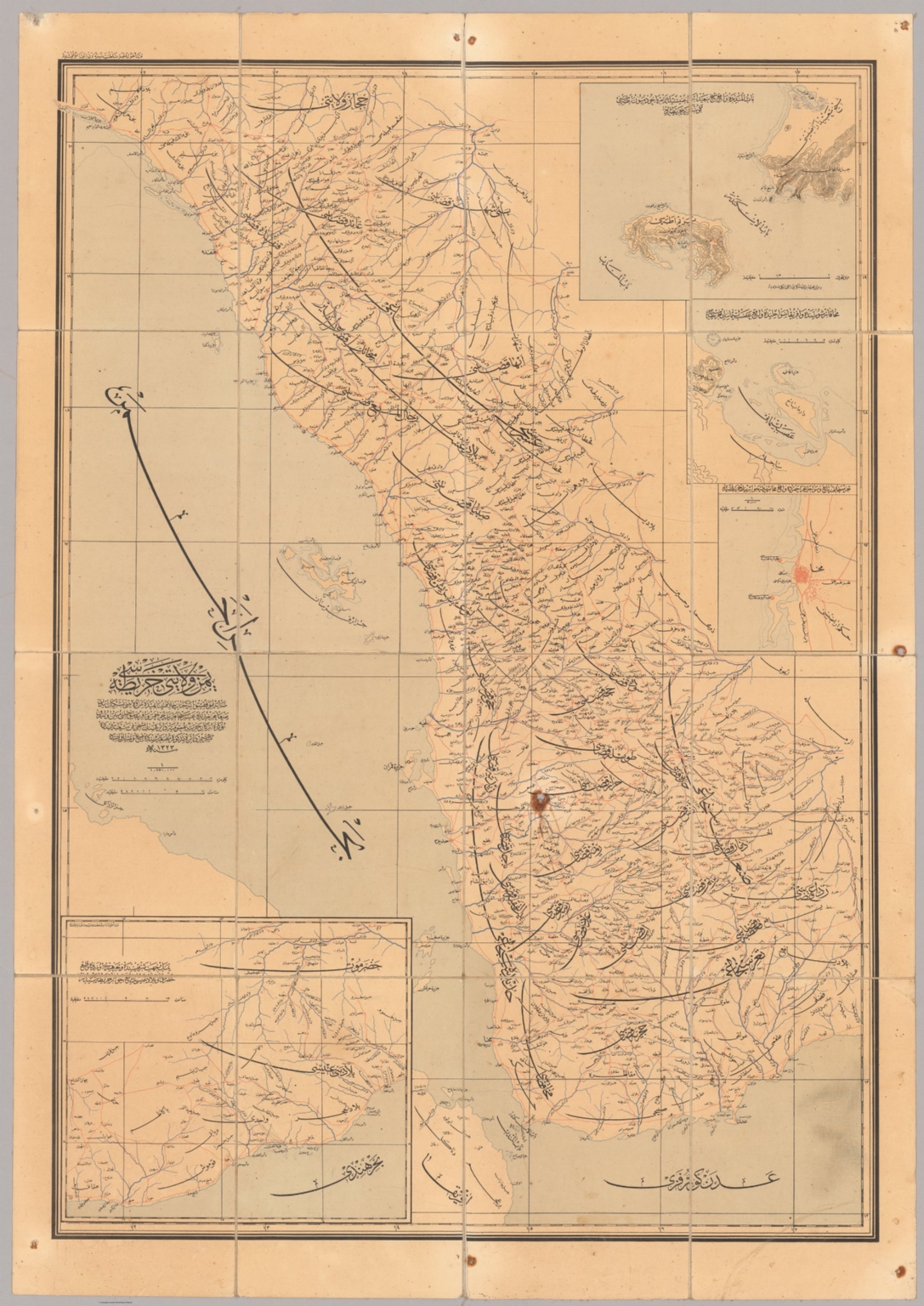
يمن ولايتى خريطة سى [Yemen Vilâyeti haritasi / Map of Yemen Vilayet].
اركان حربيه عموميه دائره [Erkan-i Harbiye Umumiye Daire Matbaasi / General Military Office Press], Istanbul, 1907
Online
Karte
Zugriff:
"Extremely rare - one of the two seminal printed Ottoman maps of Yemen, with the Asir, Jizan and Al Bahah areas of today’s Saudi Arabia, being the first scientific map of the region, predicated advanced surveys made by Ottoman Army Engineers completed during the Zaidi Rebellion (1904-11) in Yemen and the Idrisid Rebellion (1906-10) in Asir, which led large Ottoman army expeditions to traverse the interior; issued in Istanbul for the Ottoman War Ministry; its unprecedented degree of accuracy and high level of detail made it the apogee of the Ottoman mapping of Yemen and Asir, and it remained the authoritative operational and strategic guide for region until World War II. This extremely rare and important map represents the apogee of the Ottoman cartography of Yemen, and the regions of Asir, Jizan and Al Bahah (today part of Saudi Arabia), then de jure parts of the Ottoman Empire, but which were de facto largely under the control of various local potentates. It is the result of over a decade of surveys conducted by Ottoman Military Engineers, principally of its Fifth Drafting Department of the General Military Office (an elite surveying and reconnaissance unit), working under unimaginably difficult conditions, in the run up to and during the period when the greater region was inflamed by unrest, in the form of the Zaidi Rebellion (1904-11) in Yemen and the Idrisid Rebellion (1906-10) in Asir. Creating the map was a priority for the Ottomans, as a stellar knowledge of the forbidding interior was necessary for them to have any chance of combatting what were determined and skillfully led guerrilla insurgencies. The map is predicated upon trigonometrical survey of the major settled areas and transportation corridors, anchored basepoints determined by astronomical observations, making it the first scientific and planimetrically accurate map of Yemen and Asir, etc. The large-format, separately issued map was lithographed in 1907, in Istanbul, for the Erkan-ı Harbiye Umumiye (Ottoman War Ministry). The main map embraces all of Ottoman Yemen (North Yemen), the western part of the British Protectorate of Aden (South Yemen), while in the north the map extends as far as Al-Lith, in the Mecca region, so embracing of Asir, Jizan and Al Bahah. The coastlines are detailed with scientific precision, with all major rivers are depicted. Every city and town of any note is labelled, all fortis are marked, while the intricate network of roads and caravan routes, with the high roads emphasized, is portrayed in unprecedented detail, providing all the information needed to guide military movement. The map is augmented by four insets, with the one in the lower left corner depicting the Hadramawt (the western part of the Protectorate of Yemen); with in the upper right are the insets of the famed coffee port of Mocha (lower); Assab (centre, the port in Italian of Eritrea, just across the Red Sea from Yemen, which was of great strategic interest the Ottomans, as only four years later they would be at war with Italy); and, finally, a map of the Bab-el-Mandeb (top, the ‘Gate of Tears), marking the entrance to the Red Sea, with the strategically-placed British naval station of Perim Island and the adjacent mainland point of Ras Sheikh Said, home to a key ottoman fort, near the boundary between Ottoman and British Yemen. The present work is one of the two seminal Ottoman printed maps of Yemen and Asir, etc. It is the successor map of the first broadly accurate map of the region, Colonel Ahmed Muhtar’s Yemen Vilâyeti haritasi... (The Ottoman Vilayet of Yemen…) (Istanbul: Erkan-ı Harbiye Umumiye Matbaası, 1304 [1888]), a colossal composition (measuring 113 x 245 cm), that while an incredible accomplishment, being far more detailed than the present work, was nevertheless only semi-scientific, so was markedly less planimetrically accurate. One problem with the earlier map was that it was so large and heavy that it was far from ideal for field use and, as such, it had very limited operational applicability. Prior the creation of the 1888 map, the interior of Yemen and Asir, etc. was scarcely known to outsiders, and had never been charted in any serious sense due to the perceived hostility of the locals and the incredibly rugged, sunbaked nature of the landscape, although the coastlines had long been scientifically surveyed by the British Royal Navy. The present map, while still of a large format, could easily be carried by soldiers on horseback and consulted in the mountains and deserts during active campaigning. Its high accuracy, and fine level of detail rendered it a vital tool for operational planning, guiding military movement along the caravan routes towards bases and expected siege points. Like its predecessors, its relatively large scale would have allowed generals at headquarters, or those at the Sultan’s court in Istanbul, to consult the map for strategic planning (i.e., where to allocate resources in a general sense). As things turned out, the Ottomans would end up losing control over Asir in 1910 (the Idrisids having been successful in their revolt), while in Yemen they fought the Zaidis to a stalemate, resulting in the Sultan granting them effective local autonomy. However, the present work would remain by far and away the most accurate and authoritative map of the region (save for South Yemen, which was scientifically surveyed by the British) until the region was exactingly mapped during World War II. A Note on Rarity The present map is extremely rare. An expensive and informationally sensitive work, it would have been published in only a small print run, exclusively for use by senior Ottoman officers and politicians, while the survival rate of such large maps destined for active war zones is very low. We can locate only a single institutional example of the map, held by the University of Istanbul Library. Beyond that, we are aware of only 2 other examples of the map as having appeared on the market, being an example offered 3 years ago by a London dealer, as well as a record from an Istanbul auction. A Brief History of Ottoman Yemen & the Yemeni, or Zaidi, Rebellion of 1904-11 Yemen is one of the most ancient and culturally rich lands in the Middle East. It was traditionally also the source of great wealth; its interior produced coffee and silver, while its coastal ports were for millennia great marts of trade. Its strategic location often ensured that control of Yemen led to naval dominance of the Red Sea, a vital maritime link between South and East Asia and Europe. Yemen has also been closely associated with the regions of Asir, Jizan and Al Bahah (today in Saudi Arabia), located immediately to the north. At times these areas were parts of the political entity of Yemen, although they had their own distinct cultural identities. Asir was a valuable territory, as its relatively well-watered highlands were the most productive agricultural area in the entire Arabian Peninsula, capable of producing large yields of grains and fruits. Importantly, as in most many other parts of Arabia, practical power on a day to day basis was exercised by local tribal or village leaders, under the loose suzerainty of regional or imperial masters. Nobody ever comprehensively controlled Yemen and Asir on the ground, that was not the nature of region and its socities. For some generations up until the early 16th Century, much of Yemen and Asir was loosely ruled by the Mameluke Sultanate, which was based in Cairo. After the Ottomans vanquished the Mamelukes in 1517, a power vacuum ensued in Southern Arabia, leading to intense conflict between local powers. The Zaidi Imams were a dynasty led by scholar-warriors who representing a large Shia community in the Yemeni highlands, based in the great city of Sana’a. They were the leading power in the region, although their position was contested by local rivals. Meanwhile, The Ottomans secured Hejaz, with the holy cities of Mecca and Medina, which allowed the Ottoman Sultan to possess the title of Caliph, the defender of Islam. In 1538, the Zaidi Imamate, seeking protection from their regional rivals, invited the Ottoman army to come to Yemen, and to make the region a de jure part of the Ottoman Empire, while permitting the imam to maintain his internal autonomy. The Ottomans established the Eyelet of Yemen, and proceeded to extend their control along the tihama, while keeping a small garrison in Sana’a. For some decades, the Ottoman presence succeeded in buttressing the Zaidi regime, although the Sublime Porte’s authority over much of the country outside of main centres was weak. It is important to note that the Ottomans and the Zaidis were not natural allies; their outlooks differed greatly, starting with their conflicting Sunni-Shia theological identities. From the eyelet’s capital, the port of Mocha, the Ottomans derived considerable revenue from trading in the region’s commodities and slaves, while their presence in Yemen anchored their control of the Red Sea. However, the Ottomans eventually faced effective resistance from communities in the interior. Notably, the Zaidi imam Qasim the Great (ruled 1597-1620), came to resent the Ottoman presence in his country. He expelled the Ottomans from Sana’a and mounted a brutally effective guerrilla war against them. This cause was carried on by his son, Muhammad, and the Ottomans withdrew from Yemen altogether in 1636. The Zaidis then proceeded to conquer almost all of Yemen and Asir, creating one of the Middle East’s largest and most prosperous states. During the 18th century, Zaidi rule over most of the Yemen and Asir gradually collapsed. While the imamate retained control of Sana’a and its vicinity, the country fragmented under into the rule of numerous local potentates. The Ottomans, facing crises in the Caucuses and Balkans, showed little interest the region. In 1805, the religiously arch-conservative Wahhabis sprang with shocking speed and force out of their homeland in the desserts of the Nejd to conquer the holy cities of Mecca and Medina. This was a catastrophe for the Sublime Porte, as the loss of the holy cities undermined the Sultans’ claim to the Caliphate, which was, in many cases, the only thing that legitimized his rule over non-Turkish Muslims. Muhammad Ali, the Ottoman Viceroy of Egypt, was tasked with regaining control of the holy cities in the name of the sultan. This was achieved in 1811, after which he meted out harsh justice upon the Wahhabis. Nevertheless, the, albeit temporary, loss of Mecca and left the Sublime Porte rattled. Meanwhile, the situation in Yemen and Asir remained quite unstable, with the lobal powers likewise shaken by the Wahhabi surge into nearby Hejaz (the Shai Zaidi Imams held a special antipathy towards the Wahabis). During the First Ottoman Egyptian War (1831-3), Muhammed Ali rebelled against Ottoman rule and successfully took over Egypt, the Levant and Hejaz. He also managed to extend his authority along the tihama of Azir and Yemen, although his influence there was never strong. The Viceroy’s forces almost caused the collapse of the Sublime Porte in Turkey, before being convinced to back down. The Egyptians agreed to recognize the Sultan as their overlord, but only in the most technical sense; much of the Middle East would be, for all practical purposes, ruled from Cairo. Meanwhile, Yemen’s strategic location, guarding the Bab-el-Mandeb, the nexus between the Red Sea and Indian Ocean, came to the forefront of global geopolitics. Britain was alarmed by Muhammed Ali’s expansion, fearing that it could threaten Britain’s all-important interests in the Indian Ocean. In 1839, they founded a naval base at Aden, a stellar natural harbour on the Indian Ocean coast of Yemen. Following the Second Egyptian–Ottoman War (1840-1), Britain pressured Muhammed Ali into backing down. He agreed to essentially become the head of an autonomous dynasty in Egypt and Sudan in return for restoring Ottoman rule over the Levant and Hejaz. Egyptian forces where withdrawn from the tihama of Asir and Yemen, creating a power vacuum that added to the region’s instability. Even as the Egyptian thereat had been neutralized, the Sublime Porte was concerned that the growing British presence around Aden and the instability in Yemen and Asir (which bordered the Mecca region) endangered their hold on the holy cities. While initially reluctant to mount what would be a technically difficult and expensive campaign, in the late 1840s, the Ottomans decided to reclaim Asir and Yemen to shore up the empire’s position in Hejaz and Red Sea. It must be noted that this new ‘proactive’ Ottoman policy must be seen within the greater context of the Tanzimat Era (1839-76), whereupon the Sublime Porte’s comprehensive regime of reforms, including the modernisation of the military and renewed impetus to re-assert central authority in the empire’s peripheral regions. By April 1849, Ottoman expeditionary forces had taken control of the tihama of both Asir and much of Yemen, including the key port of Hodeida. Echoing the situation three centuries earlier, in July 1839, the Zaidi Imam Mohammed Yayha invited the Ottomans to come to Sana’a, where he concluded an agreement under which Zaidi lands would become subject to the Sublime Porte, while then imamate retained its local autonomy. A small Ottoman garrison was established in Sana’a, while the Sublime Porte extended its control over the tihama southwards down to the Bab-el-Mandeb, so re-establishing the Eyelet of Yemen. Perhaps predictably, the Ottomans and the Zaidi imamate soon had a falling out and the Ottoman garrison was expelled from the Sana’a. Turkish authority completely dissolved beyond the tihama. The Ottomans, preoccupied with grand faraway events, such as the Crimean War and conflicts in the Balkans, were unable to re-establish their authority beyond their coastal garrisons. This was not only because of a lack of manpower, but also due to the fact that the Ottomans possessed very scant knowledge of the geography of the interior of Asir and Yemen; they usually relied upon local guides even to traverse the highroads. As the Yemeni tribesmen who contested Ottoman rule were masters a guerrilla warfare, without a detailed knowledge of the terrain, even a large Turkish army would be doomed to ambush and entrapment. While decent sea charts of the coasts existed, the existing mapping of the interior was so vague as to be operationally worthless. The opening of the Suez Canal, controlled by France and Britain, in 1869 posed a new threat to the Ottoman control of the Hejaz and their presence in Arabia. Hitherto the Red Sea would become one of the globe’s busiest shipping lanes, with routes controlled by foreign imperialist powers. The Royal Navy centre at Aden was to be majorly upgraded into one of the world’s largest naval bases, while the British would, in 1872, declare all south-eastern Yemen to be their Aden Protectorate. Moreover, France was directing covetous eyes towards Yemen’s magnificent coffee industry. The Sublime Porte knew that it had to act fast to prevent its authority in Arabia from slipping away. In 1869, a large and well-equipped Ottoman army under Colonel Ahmed Muhtar (1839 - 1919) was sent to conquer Asir and North and Western Yemen. Ahmed Muhtar was no ordinary army commander, but a polymath scientist, writer and diplomat who while barely thirty years old had already played a critical role in modernizing the Ottoman military. The most versatile and clever Ottoman soldier of his era, he had an uncanny ability to master different battle theatres and proved to be equally adept at both guerrilla warfare in remote mountains as well as set piece field battles. Importantly, Ahmed Muhtar was a professional military engineer who placed extraordinary value on geographic knowledge and cartography. He obsessively pressed his engineers and scouts to map the terrain, before integrating this information into regional maps of Yemen. In this way the Ottomans gained the first detailed and approximately accurate body of geographical knowledge of the interior of Asir and Yemen. In this incredibly mountainous region, the attainment of such knowledge was not merely a supporting factor, but rather a pivotal, determinative issue in the success of any military campaign. Ahmed Muhtar made short work of rebels in Asir, conquering much of the region by 1871. Moving south, he easily gained mastery of the tihama. Sultan Abdulaziz II was so impressed by his success, that Ahmed Muhtar was promoted to general and pasha and made the Vali (governor) of Yemen. In 1872, Ahmed Muhtar turned his sights on the real trouble spot, the Yemeni highlands. He managed to outwit many of the tribes that lay between the coast and Sana’a. This show of force convinced the Zaidi Imam Ghalib, whose regime suffered from internal cleavages, to invite the Ottomans to come to Sana’a to make a deal. Ahmed Muhtar arrived in Sana’a in April 1872, where he was greeted with great pomp and hospitality. The Zaidi imam agreed to accept the Sultan as his overlord in return for imperial protection and the maintenance of his local autonomy. However, it would later be revealed that Ahmed Muhtar and the Imam had very different interpretations of the meaning of the accord. Ahmed Muhtar attempted to set up a modern administration in Yemen in line with the Tanzimat programme. The country became a full Ottoman vilayet (province), and was divided into four sanjaks (districts), being Sana’a, Hodeida, Asir and Taiz. Civil servants were appointed from the local tribesmen to collect taxes and customs revenues, while significant funds (at least in part derived for the local taxes) were earmarked for infrastructure development and social programs. Army units were also raised from the local population, giving steady employment to otherwise listless young men. In the key cities and some rural areas, the local people from tribal chiefs all the way on down to common peasants came to depend on the Ottoman state for their livelihoods (which was part of the Ottoman design). On the other hand, some tribes, especially those who were traditionally at odds with the Ottomans’ ‘friends’ the Zaidi Imams, continued to mount small scale rebellions across the Yemeni highlands. While these problems were kept in check, it was at a high cost, as 4,000 Ottoman troops died in Yemen between 1872 and 1875. Nevertheless, by the time Ahmed Muhtar Pasha left Yemen in September 1874, to assume his promotion as the Ottoman Minister of Public Works, he had largely succeeded in ensuring that Yemen had become an integrated part of the Ottoman Empire in the modern sense, something that nobody else would ever achieve. During the 1880s, the Ottoman Treasury was desperately short of funds owing to a public debt crisis and enacted harsh budgetary cutbacks. The empire no longer had money to give financial ‘incentives’ to Yemeni tribal leaders; many native civil servants were not paid regularly; and local army detachments were disbanded. To the Yemenis the Ottomans were no longer holding up their end of the bargain, and unrest and mini-rebellions broke out across the Yemeni highlands. The Ottomans lost control of virtually all areas to the north and east of Sana’a. It also did not help that British agents were soliciting the tribes in the far south, near Taiz, to join the Aden Protectorate. The Ottoman army soon found itself constantly moving about the country ‘putting out fires’, fighting a seemingly endless struggle to regain control. However, the constant military movement and the need to repair infrastructure, gave the Ottoman military engineers, particularly of the Fifth Drafting Department of the General Military Office, the opportunity to conduct the first scientific surveys of the interior of Yemen, leading to the creation of the present map. The Zaidi Imamate, hitherto the bedrock of the Ottoman regime in Yemeni highlands contemplated switching sides. The Zaidis never liked Ahmed Muhtar’s modernizing programme; they felt that creating a ‘modern’ Yemen violated their autonomy and traditions. As Shiites they also came to find many of the religious practices of the mainly Sunni Ottoman forces to be disagreeable. The Zaidi feigned a rebellion in 1891, before calling it off; however, the bloom was off the rose and relations between Constantinople and Sana’a continued to deteriorate. In 1904, the new Zaid Imam Yahya Muhammad Hamid ed-Din, or simply Imam Yahya (1869 – 1948) mounted a full-scale rebellion against Ottoman rule. A highly intelligent and discipled leader, his guerrilla tactics outmatched the Sultan’s overstretched forces and the Ottomans were virtually driven out of the Yemeni highlands. After years of hard fighting wore down both parties, the Imam and the Sublime Porte signed the Treaty of Da’an (1911), which settled matters largely on the Zaidi terms; essentially the Zaidis would rule much of Ottoman Yemen, with only very light Ottoman oversight. Meanwhile, the Ottomans were also having trouble in Asir, as beginning in 1906 the local leader Muhammad ibn Ali al-Idrisi rebelled against the Sublime Porte. The Idrisids succeeding in driving the Ottomans out of much of Asir and Jizan by 1910, forming the Idrisid Emirate of Asir. The Idrisids were enemies of the Zaidis, so the new reality in Yemen was very tense. Yemen was a key theatre in World War I, with the Zaidis supporting the Ottomans, while the British backed the Idrisids. The Ottoman Empire collapsed upon the end of the conflict in 1918, whereupon Imam Yayha declared himself ruler of the Mutawakkilite Kingdom of Yemen, forming a regime that would persist until 1962 (after which the country became the Yen Arab Republic, popularly known as North Yemen). After fighting an exhausting war against the Zaidis., the Idrisids lands were absorbed into Saudi Arabia in 1934. The British continued to rule their Aden Protectorate until 1967, after which point the country became the People’s Democratic Republic of Yemen, popularly known as South Yemen. North Yemen and South Yemen were unified in 1990. Sadly, however, since 2015, Yemen’s old rivalries have retuned to fore, upon the outbreak of the ongoing Yemeni Civil War." (Alexander Johnson and Dasa Pahor, 2023)
University of Istanbul Library: IUNEK93843; Cf. (Background:) Robert T.O. WILSON, Gazetteer of Historical North-West Yemen in the Islamic Period to 1650 (1989), p. 353; Abdol Rauh YACCOB, ‘Yemeni opposition to Ottoman rule: an overview’, Proceedings of the Seminar for Arabian Studies, vol. 42, [Papers from the forty-fifth meeting of the Seminar for Arabian Studies held at the British Museum, London, 28to 30 July 2011] (2012), pp. 411-419. Not in: Osmanlı coğrafya literatürü tarihi. History of Geographical Literature during the Ottoman Period, 2000.
| Titel: |
يمن ولايتى خريطة سى [Yemen Vilâyeti haritasi / Map of Yemen Vilayet].
|
|---|---|
| Autor/in / Beteiligte Person: | اركان حربيه عموميه دائره سنك بشنجى فن شعبه سنده FIFTH DRAFTING DEPARTMENT OF THE GENERAL MILITARY OFFICE]. |
| Link: | |
| Veröffentlichung: | اركان حربيه عموميه دائره [Erkan-i Harbiye Umumiye Daire Matbaasi / General Military Office Press], Istanbul, 1907 |
| Medientyp: | Karte |
| Schlagwort: |
|
| Sonstiges: |
|