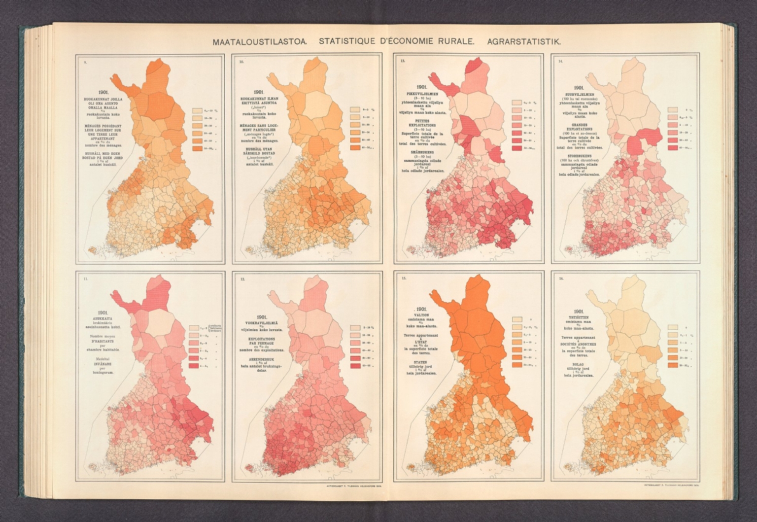
Maataloustilastoa. = Statistique d'économie rurale. = Agrarstatistik. : 9. 1901. Ruokakunnat joilla oli oma asunto omalla maalla = Ménages possédant leur logement sur une terre leur appartenant = Hushåll med egen bostad på egen jord -- 10. 1901. Ruokakunnat ilman erityistä asuntoa = Ménages sans logement particulier = Hushåll utan särskild bostad -- 11. 1901. Asukkaita asuinhuonetta kohti = Nombre d'habitants par chambre habitable = Invånare per boningsrum -- 12. 1901. Vuokraviljelmiä = Exploitations par fermage = Arrendebruk -- 13. 1901. Pikkuviljelmien yhteenlaskettu viljellyn maan ala = Superficie totale de la terre cultivée des petites exploitations = Småbrukens sammanlagda odlade jordareal -- 14. 1901. Suurviljelmien yhteenlaskettu viljellyn maan ala = Superficie totale de la terre cultivée des grandes exploitations = Storbrukens sammanlagda odlade jordareal -- 15. 1901. Valtion omistama maa = Terres appartenant à l'Etat = Staten tillhörig jord -- 16. 1901. Yhtiöitten omistama maa = Terres appartenant à sociétés anonymes = Bolag tillhörig jord. Aktiebolaget F. Tilgmann, Helsingfors 1909. : Atlas öfver Finland, 1910. Sällskapet för Finlands geografi. : Maataloustilastoa. = Statistique d'économie rurale. = Agrarstatistik. : 1. 1901. Maanviljelysväestö = Population agricole = Landtbruksbefolkning ...
Aktiebolaget F. Tilgmanns bok- och stentryckeri, Helsinki, 1901
Online
Karte
Zugriff:
Eight agricultural maps of Finland. Maps feature the statistics of rural economics, including the number of households with their own home on their own land, households without private dwellings, the number of inhabitants per habitable room, tenancy holdings, the total area of cultivated land for small holdings and large holdings, as well as land belonging to the State and to companies in 1901. Maps also show political boundaries, coastlines and islands. Maps include legends and explanatory notes. Colored lithograph. Together, maps are 38 x 56 cm, on double sheet 43 x 60 cm. Text presented in parallel Finnish, French and Swedish. Preceded by section title page for maps.
Atlas öfver Finland, by Sällskapet för Finlands geografi [Suomen Maantieteellinen Seura]; published in Helsinki, 1907. Title translates to: Atlas of Finland. Bound in dark green board with title and coat of arms for Finland on front cover, printed in white. Collation: 2° : [1-4], [I], II-III, [1], 2-7, [55] double leaves of plates. Volume comprised of a title page, editorial board list, preface, table of contents, statistical tables and 302 maps, as well as numerous charts. Maps topics include topography, geology, seismology, hydrology, climate, phytogeography, agriculture, zoology, statistics, economics, transportation, communication, linguistics, electoral politics, education and historical cartography. Maps also show cities, railways, roads, canals, bodies of water, drainage, coastlines and islands. Some maps employ data visualization to convey information, such as on light houses and the illumination they produce. For related item in collection - the first edition of the atlas, published in 1899 - see Pub List No. 14366.000. According to the preface, this edition was published because the 1899 edition "was so well received by the public in its own country and among the representatives of geographical science that continuing to work in the same direction appeared to the Society as an inalienable duty."
| Titel: |
Maataloustilastoa. = Statistique d'économie rurale. = Agrarstatistik. : 9. 1901. Ruokakunnat joilla oli oma asunto omalla maalla = Ménages possédant leur logement sur une terre leur appartenant = Hushåll med egen bostad på egen jord -- 10. 1901. Ruokakunnat ilman erityistä asuntoa = Ménages sans logement particulier = Hushåll utan särskild bostad -- 11. 1901. Asukkaita asuinhuonetta kohti = Nombre d'habitants par chambre habitable = Invånare per boningsrum -- 12. 1901. Vuokraviljelmiä = Exploitations par fermage = Arrendebruk -- 13. 1901. Pikkuviljelmien yhteenlaskettu viljellyn maan ala = Superficie totale de la terre cultivée des petites exploitations = Småbrukens sammanlagda odlade jordareal -- 14. 1901. Suurviljelmien yhteenlaskettu viljellyn maan ala = Superficie totale de la terre cultivée des grandes exploitations = Storbrukens sammanlagda odlade jordareal -- 15. 1901. Valtion omistama maa = Terres appartenant à l'Etat = Staten tillhörig jord -- 16. 1901. Yhtiöitten omistama maa = Terres appartenant à sociétés anonymes = Bolag tillhörig jord. Aktiebolaget F. Tilgmann, Helsingfors 1909. : Atlas öfver Finland, 1910. Sällskapet för Finlands geografi. : Maataloustilastoa. = Statistique d'économie rurale. = Agrarstatistik. : 1. 1901. Maanviljelysväestö = Population agricole = Landtbruksbefolkning ...
|
|---|---|
| Autor/in / Beteiligte Person: | Suomen Maantieteellinen Seura ; Tilgmann, Ferdinand, 1832-1911 |
| Link: | |
| Veröffentlichung: | Aktiebolaget F. Tilgmanns bok- och stentryckeri, Helsinki, 1901 |
| Medientyp: | Karte |
| Schlagwort: |
|
| Sonstiges: |
|